


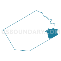
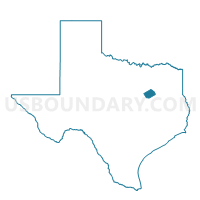
Voting District 0207, Navarro County, Texas
About
Outline

Summary
| Unique Area Identifier | 676078 |
| Name | Voting District 0207 |
| County | Navarro County |
| State | Texas |
| Area (square miles) | 65.23 |
| Land Area (square miles) | 51.97 |
| Water Area (square miles) | 13.25 |
| % of Land Area | 79.68 |
| % of Water Area | 20.32 |
| Latitude of the Internal Point | 32.03238370 |
| Longtitude of the Internal Point | -96.14212760 |
Maps

Graphs
Select a template below for downloading or customizing gragh for Voting District 0207, Navarro County, Texas


Neighbors
Neighoring Voting District (by Name) Neighboring Voting District on the Map
- Voting District 0008, Freestone County, TX
- Voting District 001T, Henderson County, TX
- Voting District 01CR, Henderson County, TX
- Voting District 0203, Navarro County, TX
- Voting District 0205, Navarro County, TX
- Voting District 0308, Navarro County, TX
Top 10 Neighboring County Subdivision (by Population) Neighboring County Subdivision on the Map
- Cedar Creek Lake CCD, Henderson County, TX (35,484)
- Corsicana CCD, Navarro County, TX (32,710)
- Fairfield CCD, Freestone County, TX (7,800)
- Kerens CCD, Navarro County, TX (3,420)
Top 10 Neighboring Unified School District (by Population) Neighboring Unified School District on the Map
- Fairfield Independent School District, TX (9,450)
- Kerens Independent School District, TX (3,652)
- Cross Roads Independent School District, TX (3,010)
- Mildred Independent School District, TX (2,830)
- Trinidad Independent School District, TX (891)
Top 10 Neighboring State Legislative District Lower Chamber (by Population) Neighboring State Legislative District Lower Chamber on the Map
Top 10 Neighboring State Legislative District Upper Chamber (by Population) Neighboring State Legislative District Upper Chamber on the Map
- State Senate District 5, TX (899,155)
- State Senate District 3, TX (818,359)
- State Senate District 22, TX (789,412)
Top 10 Neighboring 111th Congressional District (by Population) Neighboring 111th Congressional District on the Map
Top 10 Neighboring Census Tract (by Population) Neighboring Census Tract on the Map
- Census Tract 1, Freestone County, TX (5,357)
- Census Tract 9707, Navarro County, TX (5,318)
- Census Tract 9706, Navarro County, TX (3,420)
- Census Tract 9509.02, Henderson County, TX (2,085)
Top 10 Neighboring 5-Digit ZIP Code Tabulation Area (by Population) Neighboring 5-Digit ZIP Code Tabulation Area on the Map
- 75840, TX (7,076)
- 75148, TX (5,842)
- 75109, TX (3,658)
- 75144, TX (3,291)
- 75163, TX (2,285)
- 75859, TX (1,923)